Our recent weather patterns in North America in early February show dramatic weather conditions due to the winter storms on the Pacific Coast. A massive winter storm bringing a mix of heavy snow, rain and gusty winds lashed much of the US West and North the week of 4 February 2024 and put more than 60 million people across 28 states under winter weather alerts.
High winds were whipping parts of California, coinciding with tens of thousands of power outages. In California, power outages rose as strong winds swept in. More than 160,000 homes and businesses were without power as of 6.40 pm local time on Tuesday. The most outages were reported in Northern California, where wind gusts rose above 50 mph. The heaviest snow through Tuesday afternoon was across the northern Rockies.
How much affect does our lifestyle have on the weather patterns? While we are on the topic of weather, we might as well discuss climate too. It is commonly said that climate is what you expect (or predict) and weather is what you get. This is another way of saying that weather represents the conditions at a specific location on a specific day, while climate represents the average conditions over many years. Both have a great impact on how we live, but climate tends to affect lifestyle, social structure and culture, whereas weather affects daily choices such as those described above.
Weather sometimes has some less obvious effects on the way we live too. For instance, weather patterns control the ocean as well as the land. During storms, we see bigger waves that carry away more sand from our beaches and can destroy kelp forests, washing huge mats of drift kelp onto the beaches. Storms also cause a lot of run-off to wash dirt from streets into rivers and streams and out to the ocean, where they may have an impact on bacteria levels.
How do atmospheric rivers contribute to climate change?
The storm poured 2.9 inches of rain on downtown Los Angeles on Monday, breaking the daily record of 2.3 inches of rain set in 1901, according to the National Weather Service (NWS). The 7 inches of rain for Sunday and Monday made it the highest two-day rainfall total for the month of February, surpassing the previous record of 6 inches, set in 1913. While atmospheric rivers are a natural part of our hydrology, their frequency and intensity could change because of climate change.
The term ‘atmospheric river’ is defined as narrow areas in the atmosphere that transport significant amounts of moisture to areas outside of the tropics. It is like a river in the sky. While atmospheric rivers can vary greatly in size and strength, the average atmospheric river carries an amount of water vapour roughly equivalent to the average flow of water at the mouth of the Mississippi River, according to the National Oceanic and Atmospheric Administration (NOAA). When the atmospheric rivers make landfall, they often release this water vapour in the form of rain or snow.
One particular atmospheric river you may have heard of on the West Coast is sometimes referred to as the Pineapple Express. The jet stream in the sky transports humid air from the Hawaiian Islands towards California. Because the stream is filled with moisture, it can bring torrential downpours to California and heavy snow to the Sierra Nevada in the winter months.
Extratropical storms combined with high wind and high concentrations of water vapour can result in the heavy rainfall that happens when atmospheric rivers make landfall, which can also be associated with flooding, according to the NOAA. On the West Coast, particularly in California, most of the incoming rainfall is associated with atmospheric rivers and it falls during only a few storms a year. About 30%-50% of annual rainfall in the West Coast states accumulates with just a few atmospheric river events and most flood-related damages; up to 84% in the 11 western states and up to 99% at the coast.
Kelly Mahoney, a research meteorologist with NOAA, said that climate change does indicate the potential for more intense precipitation events stemming from atmospheric river events: “The changes in frequency of such events tend to depend on what part of the west coast we are talking about, and is not quite as confidently projected due to variability around patterns such as El Niño and La Niña, ie patterns that affect the placement of large-scale weather patterns like those associated with atmospheric rivers.”
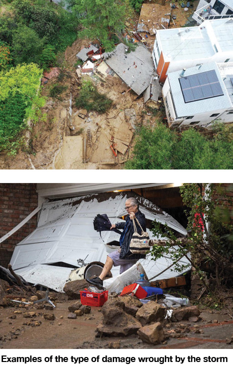
When the storm finally subsided, it left widespread damage.
A wind gust of 102 mph (164 km/h) was recorded on Sunday at Pablo Point in Marin County, just north of San Francisco, at an elevation of 932 ft (284 m). While just missing the December 1995 record of 103 mph (166 km/h) at Angel Island in San Francisco Bay, “102 is very, very impressive,” said Nicole Sarment, Meteorologist at the NWS’s Bay Area office. The top ten strongest gusts, between 102 mph and 89 mph (164 km/h and 143 km/h), recorded at the height of the weekend’s winds were all in Marin and nearby Santa Clara County, the weather service said. Gusts above 80 mph (129 km/h) were also recorded in Napa and Monterey Counties.
Information about this storm system and its damage was extracted from numerous sources, including local and national news outlets.
Comments by members
Comment by Kylie Jen
Washington, United States
Date 02/12/2025
I woke up early last 26 November, pick my phone visit site called protonreader.com to see results, California’s recent super storm really shows how extreme our weather patterns have become. With hurricane-force winds, widespread outages, and heavy snow stretching across multiple states, it’s a reminder of how closely our daily lives tie into shifting climate trends. Weather hits us in the moment—like power cuts, road closures, and coastal damage—while climate quietly shapes our long-term lifestyle and culture.